The following publications by Peter Chasseaud about British First World War trench maps, and other aspects of engineer survey (Maps and Printing Sections, Topographical Sections, Field Survey Companies, Field Survey Battalions), artillery survey, aerial photography, topographical intelligence, artillery intelligence (including sound ranging, flash spotting, air photos, etc.), etc., are at present available, several of them from Naval & Military Press.
Topopgraphy of Armaggedon - A British Trench Map Atlas of the Western Front, 1914-1918 (Mapbooks, 1991 & 1998).
Artillery's Astrologers - A History of British Survey and Mapping on the Western Front, 1914-1918 (Mapbooks, 1999).
Grasping Gallipoli - Terrain, Maps and Failure at the Dardanelles (with Peter Doyle) (Spellmount, 2005).
Rats Alley - Trench Names of the Western Front, 1914-1918 (Spellmount 2006).
skip to main |
skip to sidebar
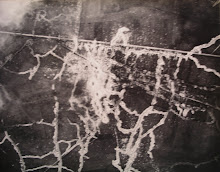
Aerial photo of the Western Front
This blog covers those aspects of my landscape work which deal with the relationship between aerial photography, landscape in its various manifestations, and mapping (particularly 1914-18 trench mapping).
My other blogs
My Peter Chasseaud Artist & Writer blog is: peterchasseaud.blogspot.com
My Tom Paine Printing Press blog is: tompainepress.blogspot.com
My Tom Paine Printing Press blog is: tompainepress.blogspot.com
Topography of Golgotha
Aerial photo of the Western Front
Blog Archive
About Me
- peter chasseaud
- I work in many media: oil painting, lithography, etching, drawing, photography, film, installations, artists books. Generally figurative and landscape, and combining images with text - I write poetic (free-verse) texts for my artists books. The images and texts have equal weight. My Kings Cross (2004), Thames - The London River (2005) and Afghanistan - A Journey (2007) books are concerned with topography, history, human culture (especially art and literature), politics, and my own memory. I am concerned with the way in which changes in technology and politics have an impact on human society, on a micro-level as in Kings Cross and Thames, or on a more macro-level as in Afghanistan. In 2007-8 I showed my artists books in London, Leeds, Bristol, Marseilles and Oxford. I am working on an art project (painting, drawing, printmaking, photography, film, willow sculpture) on willow trees in the Ypres Salient in Belgium. Also new artist's books inspired by Isaac Rosenberg's poems, and by the Euston Arch and the Euston - Camden - Chalk Farm area, and in 2009 continuing work on the East London and Borough Market areas.
No comments:
Post a Comment