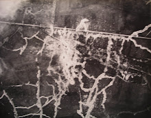
This British summer 1915 air photo shows the German front position east of St Yvon (St Yves) at Factory Farm (bottom) and a few hundred yards to the north. This position was known to the British from late 1916 as Ultra Trench (south of the road) and Ultimo Trench (north of the road). British mines were blown on 7 June 1917 under Factory Farm, a medieval moated farm known to the French and Belgians as Reebrouck ('brouck' meaning marsh), and to the Germans as Wasser-Gut (meaning water estate), and at Ultimo Trench just north of the road.
Static and dynamic interpretation.
Static interpretation reads the image as a single text - it draws out what is there, looking for characteristic signatures. In the photo above we can see a medieval and early modern cultivation system, roads and farm tracks, and a typical medieval moated farm, overlain by a relatively simple German trench and breastwork front system, with communication trenches running to the rear. The direction of light and season are given by the shadows of the trees, which are in full leaf. This photo was taken in the evening, with the low sunlight coming from the north-west. The light striking the front edge of the parapets and paradoses of trenches and breastworks, and catching the smooth, reflecting surfaces of bare earth and sandbags, contrasted with the deep shadows thrown by these features, throws them into strong relief.
Note the bulging and thickened sections of breastwork where the Germans have started building concrete shelters for their front-line garrison (particularly machine-gun crews) into and under the parapet. These were at roughly 50-metre intervals. Machine-gun positions were sited to fire along no-man's land, to take an attack in enfilade. They were not generally sited to fire to the front; this would have made their loopholes too conspicuous, and in any case was less effective in terms of a deadly field of fire.
Possible trench mortar positions can also be seen behind the German front line. We can also make out the dark band of barbed wire to the west of the German front breastwork.
A small sandbag redoubt has been built in the front line where it crosses the road.
The fall away of the ground south of the road is indicated by the shadow thrown; the level of Factory Farm is significantly below that of the St Yvon Ridge north of the road. This may explain the old name of Factory Farm - Reebrouck - 'brouck' meaning marsh.
At Factory Farm the German breastworks have been integrated with the ruins of the old farm buildings, giving a typical rectangular pattern. Tree shadows in the farm area show that it has, as yet, been relatively little bombarded, an indicator of the lack of British heavy artillery, mortars and ammunition at this stage of the war. Note how few shell holes can be seen in the whole area covered by the photo.
At the extreme left (west) of the photo is the British front line (Trench 123), a much less considerable example of field engineering, where it runs east road running northward from Le Gheer and Le Pelerin (the Birdcage). The British front line cuts back to the west (north end of Trench 123) at the highest point of the St Yvon ridge, which runs downhill from west to east towards Warneton and the River Lys.
Dynamic interpretation is much more fruitful, as it interrogates a series of images covering the same site taken at intervals of time, and draws its conclusions from the changes, or developments, between each of the series of images.
With hindsight we know that, from mid-1915, the Germans were building concrete machine-gun positions and personnel shelters (MEBUs) into their front line; these were often called pill-boxes by the British, and more recently called bunkers (a word not much used by the British in the First World War). German practice in an Allied attack was for the machine gun crews, with their machine guns and ammunition, to shelter from the preliminary artillery bombardment in these shelters (or in deep dugouts where the geology permitted), only to emerge when the bombardment had lifted. Sentries left out in the front line trench would give warning of this, and the crews would rush out and set up their machine guns in nearby shell-holes or remaining sections of trench.
1914-18 aerial photographs of the Factory Farm area reveal a rural landscape undergoing transformation under the impact of war. On the earliest surviving British (June-July 1915) air photos can be seen the pattern of roads, woods, farms, drainage ditches, cultivation boundaries, etc., and the lush vegetation of the season. The bare surfaces of roads and tracks, usually meeting at distinct angles or right-angles, show up white. Railways form long straights and gentle curves, punctuated by level crossings and/or bridges. Knowledge of the direction of light is important for differentiating between mounds and hollows; this can be deduced from shadows thrown by trees, etc. The length of shadows, related to the time of day and the season of the year, can give the height of objects. Low sunlight catches the rims of craters and shell-holes facing the sun, and casts shadows on their far side. Long, full shadows reveal hedges and the types of trees around farms and along roads and ditches – pollard willows, poplars, etc. Ground forms and features such as ditches, breastworks, banks and sunken roads are thrown into sharp relief by the raking early morning, late afternoon or evening light. Stereoscopic pairs (stereograms) make the detail stand out even more clearly, and are a great aid to interpretation.
Trenches are clearly shown as zig-zagging dark lines where they are in deep shadow, while the bare earth or sandbags forming parapet and parados, reflecting more light, show up as a pale tone or even as white. Great breastworks, built up above ground level to keep the floor of the trench above the water table, are thrown into relief by raking light and their massive dimensions made apparent (6-8 feet high, parapet some 20 feet thick, parados less thick. A thin line indicates an elbow rest, a broader line the firestep, of a fire-trench. Support and reserve trenches, splinter-proof dugouts, mortar positions and latrines can also be made out, though the last three are difficult to interpret. Machine gun positions, low in the German parapet, can be identified by the thin dark slit of their firing aperture at the foot of the parapet, by a V-shaped depression in the parapet, and by their tactically-sited position to obtain the best, usually oblique or enfilade, field of fire. Typically they were sited to fire along no man’s land, particularly where small salients or re-entrants made this possible. Where the front lines changed direction, or formed a distinct bend or dog’s leg, the machine guns were again sited to take advantage of the possibilities of enfilade fire. Barbed wire obstacles and entanglements show as dark bands in front of the fire-trenches.
Farm building and houses are easy to identify by their shape and context. Roofs catch the light. If the roofs have disappeared, the internal wall structure shows them subdivided into rectangular cells. Moated farms (hence the German name for Factory Farm: Wasser-Gut) show up clearly as a building or cluster of buildings inside a circular or rectangular water feature. Depending on the angle of light, the water in moat, pond or shell-hole can appear dark or light. After much rain, water-filled depressions can appear darker than the surrounding ground. When the snow is on the ground, the features show up black against the white ground; much more can be seen on snow photos, particularly occupied shell-holes, tracks, blast-marks, wire.
NB:
Dynamic interpretation is vital; a sequencve of images of the same site over time.
Inter-relationship of sources and images.
The air photo and terrestrial panorama photo inform the reading of the map.
The map informs the reading of the photos.
The reading of the landscape on the ground informs the reading of the map and the photos.
The map and photos inform the reading of the landscape on the ground
Everything informs everything else; symbiosis and serendipity.