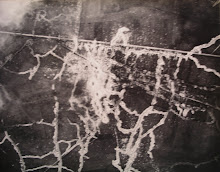
One of my landscape projects at present is working on the relationship between landscape, aerial photography and mapping in the First World War, and will be posting some of the results on this blog. My earlier books (Topography of Armageddon, Artillery's Astrologers, Rats Alley) have looked at this relationship, but my new study is taking a deeper look at aspects such as phenomenology and photogrammetry.
Showing posts with label mapping. Show all posts
Showing posts with label mapping. Show all posts
Monday, 21 July 2008
New Project; Landscape, Aerial Photography and Mapping 1914-1918
One of my landscape projects at present is working on the relationship between landscape, aerial photography and mapping in the First World War, and will be posting some of the results on this blog. My earlier books (Topography of Armageddon, Artillery's Astrologers, Rats Alley) have looked at this relationship, but my new study is taking a deeper look at aspects such as phenomenology and photogrammetry.
Subscribe to:
Posts (Atom)