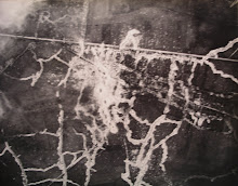
The following volume is a fascinating link between the air photo (AP) interpretation manuals produced during the First World War and the later developments in the inter-war period and the Second World War. I believe there is a copy in The National Archives at Kew. I'll post some images in due course.
Notes on the Interpretation of Air Photographs, War Office, May 1924. For Official Use Only. Air Min. 2235. ((40/Misc./2235). [HMSO] Print code: (C4357) Wt.W1149/PP2982 6/24 250 Harrow. 1 page Contents. 1 page List of Plates. Text pages 5-15. 143 plates: Photographs Reproduced by Advanced Photographic Section, AP&SS, British Army of the Rhine, covering Western Front, Rhine, Italy, Palestine, Macedonia and Gallipoli fronts. ‘This manual embodies the experience gained in the interpretation of air photographs during the stabilised periods of warfare on the various fronts between 1915 and 1918. The photographs reproduced in the plates exemplify types of work which may, or may not, be met with in the future.’ Large portrait-format album, 14” x 12”, thick buff covers, with black cloth spine. All plates are real photographs, not half-tone reproductions, except for one for guidance in interpretation of certain features (gunpits, trench mortar emplacements, etc.) which is based on wartime drawings.
I'm currently working on a book exploring the relationship between air photos and tactical maps such as artillery maps and trench maps. This will examine the developing sophistication of interpretation, and the exploitation of its fruits in the proliferation of tactical (and topographical) signs on the maps.

1 comment:
I think the site is good for customer satisfaction. One of my friends said your site better is other websites...Read More....
Post a Comment